When a massive tropical system churns toward the coastline, local news anchors drop terms like rapid intensification and storm surge as if everyone grew up with a meteorology degree. If you find yourself staring at the screen wondering what half of these phrases actually mean while packing an emergency kit, you aren't alone. Weather forecasting comes packed with proprietary jargon that can obscure real danger. Let's clear up what these phrases actually signify when a storm threatens your doorstep.
Cutting Through Spaghetti Models
You open a weather app or watch a broadcast and see a chaotic web of colorful lines sprawling across a map of the Atlantic or Gulf of Mexico. That visual is universally known as a spaghetti model, or more formally, an ensemble forecast track.
Instead of relying on a single supercomputer simulation, meteorologists run dozens of variations of the same forecast. Each line represents a slightly different computer model factoring in subtle shifts in pressure, moisture, and wind shear.
People often make the mistake of treating every line on that spaghetti plot with equal weight, or panicking because a single rogue line flashes across their hometown. Forecasters look at the cluster. The tightest grouping of lines shows where the highest probability lies. When those lines spread out wide, uncertainty skyrockets. It means the steering currents in the upper atmosphere are weak or conflicting, and nobody knows for certain where the storm will track.
The Real Danger of Rapid Intensification
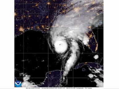
Few terms strike as much fear into emergency managers as rapid intensification. It sounds like corporate speak, but it describes a terrifying physical reality.
Under official National Hurricane Center definitions, rapid intensification occurs when a storm's maximum sustained winds increase by at least 35 miles per hour within a 24-hour period. When exceptionally warm ocean waters meet favorable atmospheric conditions, a harmless tropical depression or category one system can mutate overnight into a catastrophic monster before residents even finish clearing their patios.
The danger lies entirely in the timeline. People go to sleep thinking they have days to prepare for a manageable wind event, only to wake up to evacuation orders for a major hurricane. Relying solely on a storm's current category is a massive mistake because a weak-looking system can explode in strength hours before landfall.
Why Storm Surge Remains the Killer
Wind gets all the press because it tears roofs off houses and snaps power lines, but storm surge remains the single deadliest threat of any landfalling hurricane.
Storm surge is an abnormal rise of water generated by a storm's ferocious winds, pushing a massive dome of ocean water over the continental shelf and onto dry land. This is completely separate from heavy rainfall or normal high tides. When a powerful hurricane hits at high tide, it creates a storm tide that can submerge entire coastal communities under ten feet of water or more.
Many residents make the fatal error of thinking they can ride out a storm because their home is sturdy against wind. Water does not care how well your roof is strapped down. Inundation sweeps away foundations, flips vehicles, and leaves escape routes impassable within minutes.
The Cone of Uncertainty Trap
Another visual staple of hurricane coverage is the cone of uncertainty, which maps the projected path of the storm's center. A common misconception is that this cone represents the entire physical size of the storm.
In reality, the cone simply shows the probable track of the hurricane center over a five-day forecast period, based on historical error rates. Destructive winds, torrential rains, and dangerous storm surges frequently extend hundreds of miles outside that boundary. Focusing too much on the center line or assuming you are safe because you live just outside the edge of the cone is a dangerous gamble.
When a hurricane approaches, look past the hype and focus on local evacuation orders, flood zones, and wind hazard alerts issued by your regional weather office. Preparation is straightforward when you strip away the meteorological noise. Know your zone, heed warnings immediately, and never underestimate how fast a quiet ocean can turn hostile.